“The Serpent”
situated just below Mt Gheerulla
www.thecrag.com/climbing/australia/serpent
Access:
The start of the track to this climbing rock is only 7km from Kenilworth.
From Eumundi drive 22.5km along the Kenilworth Road to Sam Kelly Road on the left just past the Gheerulla Hall. Park in the area before the cattle grid on the right.
For responsible low impact walking ...
follow the signs to the Great Walk track, go through the locked gate and turn right onto the track to Thilba Thala. Walk 1.3km to track sign with large rock cairn on the left, follow the rough bush track for about 10 minutes to ‘the climbing rock’
NOTE: Track notes on ‘The Serpent’ website follow a rough bush track straight up to the site. These tracks are not purposely built and case erosion especially after heavy rain. The official walking track is a little longer but much easier walking.
A successful FOP grant
A group from Sunshine Coast Bushwalkers, who are also CRC members, have been doing regular track maintenance on the Conondale Range Great Walk for several years. They were successful recently in receiving a Friends of Parks (FOP) grant to carry out major track works and repairs at Peters Creek on the Great Walk.
CRC also applied for the FOP State Government grant to produce a new information brochure on the Conondales. We were unsuccessful as Parks are gearing their information delivery to the internet. While this may work well in some places, there is no mobile or internet service available at Booloumba Creek or Charlie Moreland so getting the relevant information could prove rather difficult
Great Walks Maintenance Project
"Sunshine Coast Great Walks Track Maintenance Project"
The project was submitted by the Sunshine Coast Bushwalking Club and they received a “Friends of the Parks” Grant for $8650
The project aim is to continue to provide maintenance/reporting of the Hinterland and Conondale Range Great Walks.
To re-profile a section of track below Booloumba Falls and to repair a creek crossing between Sunday Creek Road and Peters Creek on the Conondale Range Great Walk. Also they plan to purchase tools and personal protective equipment for the Volunteers.
This project is expected to provide some 1000 volunteer hours.
The ongoing maintenance part of the project will start again on Tuesday 8 July. Re-profiling work is planned to start in late July and possibly work on a creek crossing off Sunday Creek Road.
Volunteer co-ordinator, Joe Kirkpatrick contact details This email address is being protected from spambots. You need JavaScript enabled to view it.
Launch Review
11.07.04
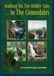
It was a tent-overfilling crowd of around 150 that gathered at Fairhill Native Plants for the launch of our book ‘Walking On The Wilder Side… in the Conondales’ and our website www.exploreconondales.com.
The colourful and informative book represented an enormous upgrade from a previous low-budget booklet of walks in the Conondale region produced by Cheryl Seabrook some years ago. Although the Conondales are a key conservation area in southeast Queensland, they have generally featured only as small sub-sections in other books.
‘Walking On The Wilder Side’ is devoted almost entirely to the Conondales, but also adds nearby walks at Gheerulla as well as the Great Walk on the Blackall Range.
More than just walks though, it is very special in including sections by a number of writers with special biological and historical expertise in the Conondales. It features the conservation history of the Conondales; how this great forest mosaic, once destined for clear-felling for hoop pine plantations, has slowly and incrementally been either added to the National Park estate or been afforded other protective tenure.
Conondale Range Committee President Ian Mackay acted as MC for the launch and welcomed guest speakers Carolyn Male [Member for Glasshouse], Richard Giles [past Project Officer for the CRC] and Mark Ricketts [long serving CRC Vice President].
All spoke of their love of, and involvement in, the Conondales, and Mark in particular, spoke of the dilemma in producing a book that would inevitably bring more people to the area. Through all our submissions over the years has been recognition of people’s needs to visit native forests, literally for ‘re-creating’. As Bob Brown puts it, “people don’t put up photos of clear-felled forests or denuded hillsides, it seems we all have a need to be somewhat in-touch with a natural world, and for many this means visiting National Park or State Forest areas. This isn’t something driven by groups like the Conondale Range Committee but in reality, this need has probably resulted in most of our wide support base over so many years.
We felt it was our special job to inform and educate visitors, a feature that is making eco-tourism the popular success that it is. We sought to inform them, not only of the forests and some of the special things that live there, but also of the protracted battle to see the area protected, firstly from rapacious clearing for farmland, then from plantation establishment and more recently from the ravages of gold mining.
A project such as this requires sustained enthusiasm and skills. Ours came from a couple of quarters. It was to Elaine Green that we owe the initial concept and hard work in securing funding from Queensland State Development and to Cheryl Seabrook that we owe the unenviable task of the myriad of functions entailed in bringing such a task to fruition.
The website, produced by a life-long visitor to the Conondales Arkin Mackay, is a ready and attractive way to access information and particularly photographs about the Conondales, purchase books and t-shirts, and generally keep up with the activities of the CRC. It will continue to grow as issues change. Do visit it at www.exploreconondales.com.
The Conondale Range Committee is indebted to the Queensland Government for funding towards this book and website. While we were able to supply the willing expertise in writing, researching, trialling walks and drives, and in collating, the assistance through funding has been the enabling factor.
Review by Ian Mackay
Launch photos by Birgit Kehr
BOOK REVIEW - Cooloola Advertiser 17.08.04
If you have never been to the Conondale Range west of Kenilworth, a new book about this significant natural forest is sure to spike your interest.
Walking on the wilder side... in the Conondales is the result of a continued effort by the Conondale Range Committee to preserve this sanctuary for generations to come.
This group rescued the Conondales - a key conservation area in South-east Queensland - from the onslaught of bulldozers and chainsaws 30 years ago when massive hoop pine plantations were planned. Since then members have sought to inform and educate visitors to the area, adding to the success of eco-tourism which recognises that people often need to visit native forests to stay in touch with the natural world.
The colourful book and a new website dedicated to the Conondales were recently launched at Fairhill Native Plants to an appreciative crowd of 150 people.
www.exploreconondales.com provides photographs and information as well as links to other sites in the area, and will grow and evolve as issues change.
Through funding from the Queensland Government, the glossy book is an enormous upgrade from previous low-budget booklets outlining various walks in the range and produced some years ago.
This new publication is more than a list of those walks. It includes sections by a number of writers with special biological and historical expertise in the Conondales, who tell the story not only of the forest and the special creatures that live within its boundaries, but also of the protracted battle to see the area protected both from the early clearing for farmland and later from plantation establishment and the ravages of gold mining.
Projects such as this require sustained enthusiam and skills and Elaine Green is credited with developing the initial concept and sourcing the funding while Cheryl Seabrook saw the project through.
Long time president of the committee Ian Mackay, a biology teacher and popular performance poet, said members were faced with a dilemma in producing the book.
While alongside the website it presents a ready way to access information and photographs about the Conondales, it would inevitably bring more people to the area. But it is hoped that through education these visitors will respect and appreciate something that has been preserved by the work of a dedicated few for the benefit of the rest of us.
Story by Kaili Parker-Price
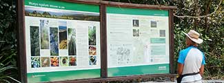
NEW! Great Walk Conondale Range
For all Great Walk enquiries contact -
www.epa.qld.gov.au/greatwalks or phone 1300 130 372, campsite bookings 13 13 04
Conondale Range Great Walk - opening Friday 2 July 2010
Access: Drive 7km south of Kenilworh to Booloumba Creek Road in the Sunshine Coast Hinterland. Or 14km from Conondale then 6km along the Booloumba Creek road, there are 2 creek crossings that require 4WD or high clearance vehicles.
There are three campsites on this 60km great walk.
Day Walks - part of great walk
The Mt Allan track from Booloumba Creek, day use area was opened at the end of September 2008.
Access: from Booloumba Creek day use area (area 2) also from area 1 camp ground, add extra 40 min return.
4hours, 10.4 (return) medium level, some steeper sectionsbut not difficult.
This is a new track up to the Mt Allan Firetower. Views from the top of the tower are spectacular and on clear day you can see Mt Cooroora, Pinbarren, Cooroy and Kenilworth Bluff. This track is the end of the Great Walk circuit
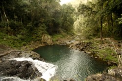
Artists Cascades on Booloumba Falls track
 The next stage of Conondale Range Great Walk to Booloumba Falls was opened on Christmas Eve 2008. The walk starts from Booloumba Area three camp ground or from the first section of the Gold Mine walk but add an extra half hour each way.
Access: from Booloumba Creek day use or campground 3.
6 to 7 hours, 17 km (return)
It is about 8km (depending where you start) each way and allow at least 3.5 hours, (7 hours return) or have a car at each end. This magnificent walk along Booloumba Creek goes past two amazing waterfalls then up to the Booloumba Breadknife and falls.
This is the first section of the 60km loop-track on the multi-day walk through the Conondale Range. The Mt Allan walk will be the last section of the Great Walk which returns to the day use area and start of the walk.
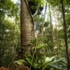
The 60km Conondale Range Great Walk will be a multi-day walk with three walkers’ camps, that showcases the rugged natural features of the area, including waterfalls, tall forests and expansive views over the range.”
The work achieved so far on the Great Walk was recognized at the official opening of the Mt Allan track by Carolyn Male.
The Conondale Range Committee would like to congratulate Mark Cody, Senior Ranger Conondale Range Great Walk and to the park staff who are building the track. It was a mammoth effort to complete the Booloumba Falls section by Christmas Eve. This section of the walk and the Mt Allan track are amazing walks that showcase the wonderful Conondales and make it accessible to all who make the effort.
Other local Great Walks
Hinterland Great Walk
Starts at Lake Baroon and goes along the Blackall Range to Mapleton then the Gheerulla circuit from Gheerulla Falls and back.
Three campsites, 58 km track.
Fraser Island Great Walk
Starts at Dilli Village to Happy Valley and includes many of the most popular lakes including Wobby and McKenzie
Eight campsites, 90 km track.
Cooloola Great Walk (opened 27 March 2010)
Total distance 90km or take the coastal route 102km. There are two main entrances the Noosa North shore and Rainbow Beach.
Four campsites, allow 5 days walking.
Mt Allan new walk officially opened
The new walking track up Mt Allan to the firetower takes approximately 4 hours (return), 10.4km. Access is from Booloumba Creek area two (day use area) or from area one camp ground, add and extra 40 minutes (return).
On Saturday 6th December Glasshouse MP Carolyn Male officially opened the first completed stage of the Conondale Great Walk. Ms Male said the historic Mt Allan fire tower was reopened ahead of the Christmas holidays following an $80,000 refurbishment.
“The Mt Allan fire tower was build in 1956 for fire reconnaissance,” Ms Male said, “It’s mainly used these days by visitors wanting to enjoy the breathtaking 360 degree views over the surrounding Conondale Range and proposed Great Walk route.”
“As with all of the Great Walks there has been thorough community consultation.
“The help of volunteers and others assisting with planning, revegation and some of the construction work has been invaluable to the overall project.
“Their involvement is testament to the commitment and pride of the local community in wanting to showcase the iconic features that make the Conondale Range such a wonderful and popular visitor destination.”
- from article in Range News.
11 December 2008
(The Mary Valley Voice 1 October 2008)
Local Muscle helps build Great Walk
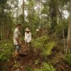
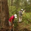
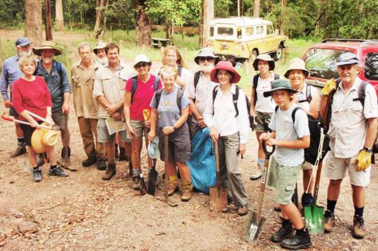
The Conondale Range Committee and friends of the Conondale National Park turned out on a recent weekend (13 September) to help with work on Mount Allan section of the Conondale Range Great Walk.
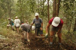 Environmental Protection Agency Senior Ranger Mark Cody said nearly 20 volunteers combined work and play on a Saturday morning to help rangers construct 100 metres of track that will be part of the Conondale Range Great Walks project.
“The help and input of local community groups such as the CRC have been invaluable in developing and progressing the project,” Mr Cody said.
“It was a great day and the work achieved here will help meet milestones in the schedule for the overall great walk project.
A barbecue lunch gave everyone the chance to relax after the morning’s efforts and some members later enjoyed an afternoon walk up the new section under development to the Mount Allan fire tower. The 5km track and refurbished tower is due for completion at the end of this month.
Work on the Great Walk is progressing with the Mount Allan section expected to be finished for the start of the school holidays.”
The Conondale Range walk is one of four new Great Walks to be constructed at a cost of $6.5 million. The others are at Cooloola, Carnarvon and the Whitsunday Islands.
“It will provide spectacular views of the valleys and deep gorges as well as mountain outlooks on the top of the range.
The walk covers a 60km circuit through stunning landscapes and allows for short day walks or overnight hikes of up to four days.
Bush walkers will be able to enjoy rainforests and tall open forests, tranquil creeks and cascading waterfalls, to magnificent viewpoints including the Mt Allan Fire Tower.”
(The Range News, December 4, 2008)
Volunteers’ big effort
The Conondale Range Committee gathered again last weekend, (29 November) to help complete the first day section of the Conondale Range Great Walk ahead of next weekend’s community event.
Environmental Protection Agency Senior Ranger Mark Cody said work had been “stepped up” to ensure 12km of track along the lower Booloumba section of the Conondale Range Great Walk was completed before Christmas.
“This section will make up the first section of the 60km loop-track on the multi-day walk through the Conondale Range.
“Additional EPA staff joined the core Great Walk construction crew at a temporary camp along Booloumba Creek to get the most out of the longer summer days.”
Mr Cody said the help of the CRC had been invaluable in delivering a first-class long distance walking trail in the Conondale Range, and 16 local members put in a big morning’s effort to deliver another 100 metres of completed walking track in difficult terrain.
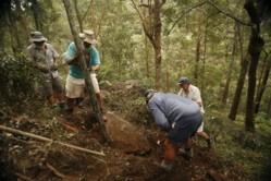 “The work included moving large rock, constructing steps and retaining walls to create the finished track,” he said.
“The 60km Conondale Range Great Walk will be a multi-day walk with three walkers’ camps, that showcases the rugged natural features of the area, including waterfalls, tall forests and expansive views over the range.”
The work achieved so far on the Great Walk will be recognized this Saturday, weather permitting at the official opening of the recently completed Mount Allan walking trail and refurbished timber fire tower.
(article by Environmental Protection Agency)
For Conondale Range Committee Enquires, contact Cheryl Seabrook [Secretary]
Postal:
PO Box 150,
Kenilworth QLD 4574
AUSTRALIA
Email: This email address is being protected from spambots. You need JavaScript enabled to view it.
For all Camping & Great Walk enquiries contact -
www.qld.gov.au/camping or 13 13 04
or
Kenilworth Office (DERM)
(07) 54460925 (Office Hours)
- You are here:
-
Home

-
Great Walk
-
General
- Information
 Walking on the Wilder Side
.. in the Conondales.
A new book of history, information, walks and activities for the Conondale Range region
Buy a copy
Reviews